So, you want to make measurements. Well of course. But how do you know you are correct ?
Let’s introduce you to the way we address measurement techniques at Orbit GT.
First of all, all measurement functions have equal means of interaction : just point and click. Between multiple clicks, you can navigate freely, use a different view window, change view mode (e.g. from 3D point cloud to spherical image), and just continue with the next click. Double click to end. During measurement, you can even edit a previous click or delete it to try again.
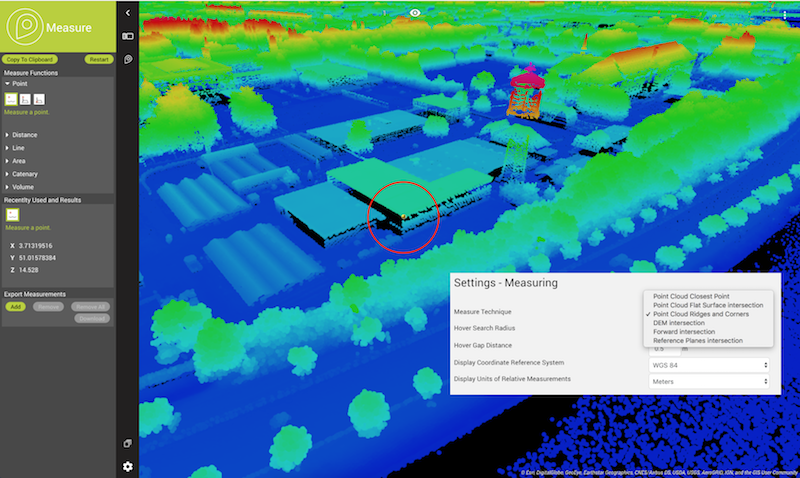
Now here’s the extra. The way a mouse click generates an intersection with the data, can be quite different indeed. Here are a few examples :
- Snap to nearest point : Where-ever you click, snap to the nearest point from the point cloud. This implements you have a point cloud available. This method works in every View mode, so you can click on an image and have the measurement calculated based on the point cloud.
- Flat Surface Intersection : Where-ever you click, a sample of points from the point cloud will allow to calculate a best-fit plane. The center point of that plane will be registered. Same here about the View mode.
- Ridge Detection : If you click near a ridge. the click will be adjusted to the nearest location exactly on the ridge. Therefore, a double surface detection is applied on the fly. Same here about the View mode.
- Mesh or TIN : An intersection with the nearest triangle of the Mesh/TIN is calculated. Same here about the View mode.
- DEM : An intersection with the DEM is calculated. Same here about the View mode.
- Forward Intersection : If no point cloud or Mesh/TIN/DEM is present, you will need to choose 2 images and measure an object from both images. This is a copy of the good-old traditional surveying and is ideal for Image-Only resources.
- Reference Planes : Finally, if you only have imagery and don’t want to use Forward Intersection, we can use reference planes to intersect with so you can measure in an image with 1 click. You may want to set the reference ground height properly before using this measurement technique.
In advanced environments, the technique can be represented by a hover providing visual feedback to anticipate on the result. This is the case in Orbit GT’s desktop portfolio.

In 3D Mapping Cloud, you can determine which measurement technique you want to use as primary setting. Remember that, when a technique cannot be executed, a fallback to the next technique will be automatically applied.