Product
Orbit 3DM CLOUD
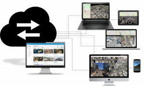
WORLD-CLASS REALITY DATA SHARING SOLUTION
Orbit 3DM Cloud is Bentley’s most powerful SaaS-based platform for uploading, storing, sharing, and viewing mobile, aerial, indoor, and terrestrial mapping data. A unique ‘plug-and-play’ solution to integrate your unlimited volumes of LiDAR, imagery, textured meshes, and GIS resources in Bentley’s or any 3rd party software workflow.

STEPS TO TAKE
UPLOAD & STORE
Prepare all your reality data for optimal streaming using desktop data management software. Upload and store these unlimited data volumes in your closest regional data center.
MANAGE & SHARE
Tweek your personal sharing environment. Manage access rights to align with security policies. Go live and share the prepared view with customers, contractors, the public, or your colleagues.
VIEW & INTEGRATE
Advanced web or plugin-based access to any of your shared views. Capabilities to measure, annotate, analyse, inspect, and export the created results. Maximize your benefits in the digital reality!